A Spring Weekend on the Upper McKenzie River

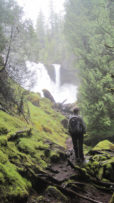
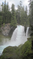
The season’s first warm weather brought significant snowmelt into the McKenzie River watershed and over the majestic Sahalie Falls and Koosah Falls.

Trip Report:
Volunteer Leader: Mark Hougardy | Organization: Eugene-based Hiking Club | Dates: May 2018 | Participants: 5 | Type: Hiking and Car Camping

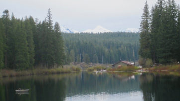
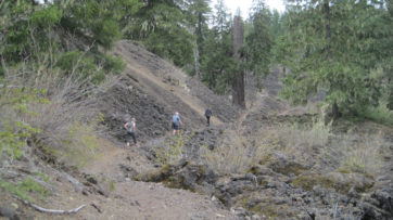
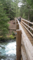
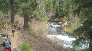
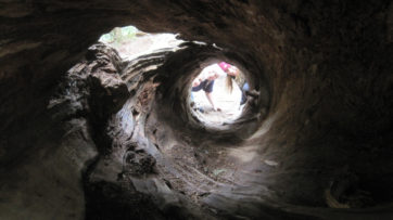
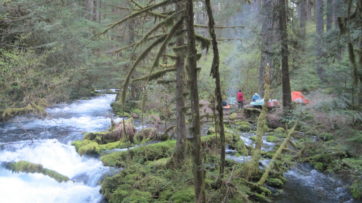
Our plan to hike to Tamolitch Falls (Blue Pool) was cut short when a sign stated a mile of trail was closed because water had flooded the path in places to a depth of 3 feet. Even with the closure, there was plenty to appreciate further upstream at Clear Lake with its crystalline waters and turquoise colored Great Spring. Animals that were seen along the trail also appeared to appreciate the warmer weather as fish jumped in the lake, several species of birds flew overhead, and a garter snake warmed itself on the rocks. In shaded areas winter still managed to hold its grip as large patches of snow remained. Springs spontaneously appeared on the trail sometimes forming small ponds, and at one point, all of us were mesmerized by a plate-sized vortex that had formed in such a pool. After a solid day of hiking, we visited Belknap Hot Springs for a relaxing soak. Because we timed our visit before the Memorial Day crowds the U.S. Forest Service campground was basically empty. Our campsite was green with moss and located next to a white rushing stream that looked like it was born from a Tolkien novel. The next day we enjoyed the comfort of a morning campfire, broke camp, and explored several more miles of trail before heading home.


Trail of Ten Falls, Silver Falls State Park

Imagine a child’s crayon drawing. The picture is populated with waterfalls, the iconic kind; horizontal on top, descending from great heights and sleek. The crayon water pours into white and blue rounded pools. The water streams from the pool to waterfall from pool to waterfall, repeating over and over again. Between the falls exists an immense green forest. Lines of color that streak in multiple directions as though a hand rapidly drew across the paper filling in all the blank areas. Woven around the falls and through the forest is a tan zig-zag trail. Here a stick-figure human explores the colorful world created for it. Now, imagine the young artist pointing to the stick figure, and with a toothy grin exclaiming, “That’s me by the waterfalls!”

If you thought such a world only existed within the mind of a child, look no further than the Trail of Ten Falls at Oregon’s Silver Falls State Park. Within a five-hour hike, your inner child can see ten fantastic and majestic waterfalls in under a 9-mile loop.

The most popular waterfall is South Falls. It begins as a gentle stream then suddenly plummets 177 feet into a misty pool. The scene is dramatic. Visitors can easily walk a loop trail behind the falls or enjoy views from a footbridge.

Located about a mile downstream is the Lower South Falls. Here the trail descends abruptly – by more than 180 steps – then sneaks behind the roaring 93-foot torrent allowing the visitor to see the world from behind a shimmering curtain of water.

The trail turns up Silver Creek revealing dozens of tiny waterfalls gushing from the side of the hill. In some areas, a hand gently placed on a moss-lined wall of green carpet disgorges water like a sponge when squeezed.

The 30-foot Lower North Falls gush into an azure basin. A nearby trail spur guides visitors to see Double Falls, a double drop, with a combined height of 178 feet, the tallest in the park.

A short distance upstream is Drake Falls. This is the smallest in the park, but at 27 feet they this grand cascade is a beauty. The falls were named after June Drake, whose early photographic work brought attention to the area and ultimately helped with the areas protection.

The North Middle Falls roar as water drops 106 feet over the top then crashes onto rocks underneath. Visitors can take a short side trail that allows them to walk behind this liquid veil – the water rumbles past just a few feet away.

Next, we take a side trail to the graceful looking Winter Falls. Standing at the base a visitor looks up 134 feet to the top. As the name implies Winter Falls is best viewed during the winter and spring seasons.

Twin Falls, at 31 feet, received its name from rocks in the streambed that splits the water forming two cascades.

The North Falls is powerful and thunderous. The water channels through a notch in the creek bed then is jetted into a canyon 136 feet below. Behind the waterfall is an impressive cavernous cutout that is almost like entering a different realm; water drips over the upper canyon wall forming a curtain of water across the path. Inside the cavernous area, ferns grow upside down on the ceiling. But, what really grabs you is the thunderous sound of water, which is a loud as a freight train when it passes frightfully close.

A short distance upstream is the Upper North Falls, a beautiful 65-foot cascade that plunges into a picturesque and deep pool. Often overlooked by visitors these falls are not to be missed.

The trail returns through the forest to the parking area near South Falls. Winter is a great time to visit; the park is less crowded, the falls are at maximum flow, and everything in the forest is green.

Silver Falls State Park is located less than an hours drive east of Salem, Oregon.

Learn more:
http://www.oregonstateparks.org/park_211.php

The Captivating Burney Falls

The 129-foot Burney Falls in northern California is one of the state’s most beautiful waterfalls.

The water does not simply pour over the top, rather the porous volcanic rock in the area encourages a dispersal of the water, resulting in multiple cascades that leap from the rock’s face along the entire height of the blue and white waterfall.

The most popular vantage point for viewing is from the base of the falls, but this area can be crowded in the summer as heat-weary visitors find refuge in the coolness.

A short loop trail allows visitors to explore both sides of the creek above and below the falls. However, if you are up for a larger hike try hiking a couple of miles of the Pacific Crest Trail, which passes next to the falls.
The campground can be very crowded in the summertime, and the visitors, not the quietest. If possible, try visiting during a down season or mid-week.

A Peek Inside Silver Falls State Park

Upper North FallsIf you have the opportunity to explore Silver Falls State Park in Oregon it is well worth the visit.

During a trip to the Beaver State, a short drive off Interstate 5 led me through farm fields and green pastures to the lower elevations of the Cascade Mountains. As the elevation increased Douglas Fir and cedar trees carpeted the countryside until I was in a forest of green.

Inside the park, I stopped at the small parking area called the North Falls trailhead. From here it was a ten-minute walk along an easy path to the Upper North Falls. Ferns and moss carpeted the sides of trails and the cool moist air was invigorating. The falls were impressive – falling 65 feet (20m) into a deep emerald colored pool. The roar from the water would have made speaking a little difficult to hear, but there was no need to talk.

In the opposite direction, past the parking area, was a short walk to the North Falls. Bordering the trail the North Fork of Silver Creek cascaded over boulders and rocks, then the water vanished from sight – and was replaced with an audible roar. A few more steps brought me to a good vantage point – the view was literally jaw-dropping.

North FallsThe stream was in free fall over a 136 feet (41 m) cliff. The water appeared to hang in mid-air for a moment then in slow motion fell onto car-sized boulders and into a deep blue-green colored pool at the base. Behind the waterfall was a dark overhang, cave-like, colored with green moss and plants. The shape of the valley was reminiscent of the old wrap around Cinemascope movie theaters. Across the valley, some hikers had walked along the Canyon Trail near the base of the falls. They appeared to be mesmerized by the sight of the falling water and stood transfixed for several minutes in awe of the performance. After some time we continued on our way to the next area.

Driving down the road we made a stop at the North Falls Viewpoint. It was a fantastic perspective of the falls we had just visited. We were roughly a quarter of a mile distant; the falls appeared to our front and center in a perfect photograph framed with green forest.

South FallsAt the main area of the park, we walked along a cobbled path and along the South Fork of Silver Creek. Here the stream is graceful and gently flows through a green and tranquil area; then there is an absence of the ground; the water of the entire stream dramatically plunges 177 feet (54 m) over South Falls into a pool below. The mouth of the pool is at the base of a giant horseshoe-shaped depression for the water to pour into. Gray rocks line the overhanging cliff and green moisture-loving plants accentuated the entire scene – it was a gift to see.

Below the falls was a trail known as the ‘Trail of Ten Falls.’ This 8.7-mile footpath takes day trip explorers to see ten beautiful falls; including the ones we just saw. I will be returning to visit this trail and see more of the park. My short trip that day was only an enticement to see more!

The day use fee at the park was $5 – and well worth it. We had to use an ‘Iron Ranger’ to pay our fee, so bring some smaller bills to place in the envelope as making a change might be difficult. Our visit was before the busy season and the water fountains were turned off making filling up our water containers difficult. The folks in the Nature Store offered us some water from their sink – which we gladly accepted – and we offered a few dollars to their donation jar in good faith. If you come before or after the summer months bring some extra water or filtering device so you will not be thirsty. Based on the size of several parking lots and distance (about 30 miles from Salem) this park receives some high visitation during weekend and summer months. If you want fewer crowds visit during mid-week or during off times.

To explore more visit the park online:
http://www.oregonstateparks.org/park_211.php

A Day Exploring the Waterfalls of Big Basin Redwoods State Park

blog_20101230_img6Winter can be a wonderful time to visit Big Basin Redwoods State Park in California.

We arrived at 10 a.m. (December 29th) and parked across from the old log building known as Big Basin Headquarters. The temperature outside was 44 degrees and the damp air was crisp. The morning clouds had dissipated and sunlight streaked through the forest canopy onto the ground below.

Surrounding the headquarters were goliaths – redwood trees that were 4, 5, and 6 feet across. One tree appeared to be 8 or 9 feet at the base. Even though I have visited here many times I am always impressed by the size and grandeur of these magnificent trees. But, today my family was here to see other sights – three magnificent waterfalls: Berry Creek Falls, Silver Falls, and Golden Cascade.

We made sure our water bottles were full before crossing over Waddell Creek and onto the Skyline-to-the-Sea trail that would lead us to the waterfalls. The winter rains had made the forest green with color. The forest was quiet, peaceful and restorative.

After an hour or so of walking through the redwoods, the sounds of rushing water could be heard. The creek next to us, Kelly Creek, was alive with water and small cascades. Everything around was green and moist. The redwoods towered above us. The only sounds we heard were our breathing and our footsteps on the ground made gentle gushing noises as we walked on the damp trail. The cleanliness of the air was a joy to breathe! Something small at the side of the trail moved ahead of us, it was a newt that was slowly traversing the fallen logs and fern fronds.

blog_20101230_img5At the Timms Creek trail junction, a fallen redwood had created a natural bridge (shown). Big Basin Redwoods State ParkWe rested and played here for a few minutes then continued on. Soon, a rock overlook along the trail let us peer down onto Kelly Creek – a myriad of small white cascades dotted the creek, large brown boulders sat among ferns and broad-leafed plants and a color chart of green moss dotted the sides of trees.

The trail descended and crossed over a small footbridge. In a few minutes, we rounded a corner – ahead of us were the Berry Creek Falls.

These 65-foot falls drop vertically – plunging abruptly into a valley of redwoods and moss. To say this is ‘picturesque’ is an understatement.

We enjoyed the view then continued to a viewing platform about three-quarters the height of the falls for a direct look (shown is the view from the platform). For ten minutes we had this view all to ourselves. Then several other hikers arrived, they deserved the same tranquility we just enjoyed, so we moved on.

Big Basin Redwoods State ParkThe trail continued upstream for about twenty minutes. Small cascades danced in the creek and gurgles of water made curious sounds as pools emptied over steep rocks. Here we saw a huge, bright yellow, banana slug about seven inches in length next to the trail. We had seen several banana slugs on the trail but this was by far the largest. The sound of falling water was coming from just up the trail.

Silver Falls began to appear through the redwoods. These falls were slightly hidden by the mass of trees, blog_20101230_img4but it was easy to see the white and frothy ‘silvery’ water as it poured over the top and dropped a wonderful 60 feet or so into a pool below. A series of stairs on the trail wound up the side of the valley to the top of the falls. At the top was a single cable handrail (shown in the photo). The trail was a little slick so we proceeded with caution.

In just seconds we were at the Golden Cascade. These were actually two cascades; at the base was a vertical fall of about 15 feet, just above it was a much more impressive drop. I am not sure about the height, but for perspective notice the blog_20101230_img3person in the photo (top right, wearing a red vest).

We enjoyed a well-deserved snack in this tranquil place then continued on our hike back to the car. Although it was an hour before sunset it was close to dark when we arrived at the parking area. These are some deep valleys and the trees are very, very tall. It can become dark quickly in the redwood forest.

I like to visit between rainstorms when the weather grants a two to three-day rest between showers allowing the trails to harden up a little. Seeing these waterfalls in the winter (and spring) are spectacular. The summer is a great time to visit too, but the streams have less water and sometimes can become just a trickle of water as fall approaches.

On our wintertime day hike, we passed only 14 people on the trail! The loop took us about 6 hours to complete and required roughly 11 miles of hiking – it is strenuous. This is a hike for families with older kids.

Big Basin Redwoods State Park was established in 1902 and was California’s first state park.

Big Basin is located a one hour drive from Saratoga, California and roughly half an hour from the town of Boulder Creek. The entrance fee is $10.

To continue your own explorations of Big Basin Redwoods State Park visit:
http://www.parks.ca.gov/default.asp?page_id=540

Sequoia’s Tokopah Falls

Everything in Sequoia National Park is on an immense scale and Tokopah Falls is no different.

Tokopah Falls is the tallest waterfall in Sequoia National Park. Visitors can see it descend along a series of whitewater cascades, falling 1,200 feet (365 meters) in just about one mile of distance (1.6 km)!

Imagine standing in a glacial-formed valley surrounded by tall walls of granite. Before you is the beginning of the valley – a steep headwall that rises a quarter-mile to the skyline. At the skyline, a white ribbon of water plummets from a large notch in the mountain. The water rushes down the steep cliff wall, darting and jumping, twisting and turning around jumbles of boulders. Such rocks might look petite from a distance, but they are the size of houses and cars. Quickly the ribbon appears larger and has a defined movement, the cascades grow larger and closer. At the base of the waterfall, a torrent of water tumbles over a cliff – it crashes into a deep pool of rolling and exploding white. This is Tokopah Falls.

Late spring offers the most dramatic views as snowmelt swells the river; though in the summer, as the snow disappears from the mountains, it is possible for the falls to appear almost dry. Regardless of the water level, this is a beautiful area.

Getting to Tokopah Falls is an enjoyable walk through forests and meadows next to the picturesque Marble Fork of the Kaweah River. The trail is 1.7 miles (2.7 km) one-way with just 500 feet (152 meters) of elevation gain – making it a good trip for families. The trailhead is located within the Lodgepole Campground on the north side of the easy-to-see stone bridge. The bridge area has easy access to the river and on hot days visitors take full advantage of the cool water. The park’s shuttle bus makes a stop at the campground just a few steps from the trailhead.

As you walk up the trail look for an impressive stone feature called the Watchtower on the south side of the valley. It dominates the skyline, rising 1,200 feet over the valley, so it is not hard to miss. The Watchtower is so big that it is a constant companion on the way to the waterfall.

On this trail, my family has seen a variety of animals including mule deer and a black bear with two cubs. During summer the trail is used by a lot of visitors; if you want to avoid crowds travel in the early morning or late afternoon.

Hiking to Mist Falls, Kings Canyon National Park

A visit to Mist Falls in Kings Canyon National Park is one of the great sights of the park.

The hike is moderately strenuous with about 800 feet of elevation gain. The round-trip is roughly 9.2 miles and can take up to 5 hours to complete, though we took 6 hours with all of our sightseeing.

Our day began at 8 in the morning. We started at the aptly named, ‘Roads End.’ This circular loop on Highway 180 is literally the ‘end of the road’ as this main Highway in the Kings Canyon stops and doubles back. From this point, the rugged wilderness is enjoyed on foot.

Immense glaciers once ruled this place, everything has been scoured and etched in some way by their great presence. Perhaps the most dramatic result is the great canyon walls that rise from the valley floor several thousand feet.

The sand and gravel trail continued for roughly 2 miles through forests, past great boulders and along the beautiful South Fork of the Kings River. Near the Bubbs Creek Trail junction, we saw a Black Bear. It was a magnificent sight! We quietly continued on our journey and allowed the bear to enjoy his day.

At the Bubbs Creek junction, the trail begins an incline. Here the river can conceal emerald pools hidden like gems along the trail. Quickly these pools turn to gentle rapids then become a series of white-water cascades that continue all the way to the falls two miles up the trail.

We rounded a corner and met a couple who had just returned from Mist Falls. We had seen several backpackers heading into the backcountry but these folks were the first-day hikers we had met. This active couple looked to be in their early 70’s. They must have started their hike at about 6 in the morning. We asked about the distance to the falls, both smiled but one answered, “It just keeps getting better from here.”

Soon afterward we stopped on an expanse of granite. This great monolith provided a good place to rest, drink some water and have a snack. From this place, we could turn around to fully see the valley below us. The view was jaw-dropping. Describing this scene is not possible, only that the word ‘beautiful’ is a weak word to define this spectacular sight. Dominating the view, 3 miles distant, was the uniquely shaped 9,146-foot mountain called, ‘The Sphinx.’

Finally, we reached Mist Falls. We could hear a roar as white-water exploded over the falls and tumbled beneath. The wind moving over the falls carried a fine mist downstream and into the surrounding forests. It was actually chilly. After drinking in this view we continued up the trail to another vantage point. Here the river’s channel created a flume. The flume slammed into a submerged boulder and catapulted a frothy and boiling mass of water 20 feet into the air – then disappeared over the edge of the falls. Further up the trail, we found a great view overlooking the falls. It was a sight. We enjoyed some lunch and this delicious experience.

Roaring River Falls in Kings Canyon National Park

Every member of the family can enjoy a quick visit to the Roaring River Falls in Kings Canyon National Park.

The falls are beautiful, picturesque and a short distance (.4 miles/.6 Kilometers) from the parking area adjacent to Highway 180, the major road in the canyon. The paved trail leads to an overlook making this a convenient destination for all ages.

Visitors can see about 80 feet of the falls as water tumbles through a gorge and unleashes a loud roar of water and spray into a turquoise pool below. Surprisingly, this visible section is only the lower third of the falls. The rest of the falls remains hidden – except to the imagination. The trail ends at the overlook because of the steep and rugged topography.

The easy accessibility of visiting Roaring River Falls can make the trail crowded and parking hard to find on weekends and during afternoons. If possible, visit the falls in the morning or evening when your family might just be the only people witnessing the sights and sounds of this inspiring place.

Berry Creek Falls Loop Hike, Big Basin Redwoods State Park

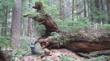
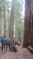
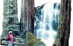
Let’s spend a day walking among giants!

Big Basin Redwoods State Park is home to thousands of impressive redwoods that tower hundreds of feet overhead.

Our 11-mile loop hike will include the Golden Cascade, Silver, and the 65 foot Berry Creek Falls.

Departure Time: 9am meet at the Sanborn Park Hostel, Saratoga, CA to determine carpools.
Re-Group Time: 10am by the Nature Center/Park Headquarters, Big Basin Redwoods State Park.
Cost: Adventurous spirit.

Bring your own water, munchies and lunch. Wear layered clothes and sturdy shoes. A change of clothes and comfortable shoes are recommended to have in the in the car for your return.

Organization: Sanborn Park Hostel
Date: May 30, 1999
Trip leader: Mark Hougardy
Participants: 12

Berry Creek Falls Loop Hike, Big Basin State Park

Join us for one of the most picturesque hikes in Big Basin. The 10.5-mile loop hike includes the remarkable Golden Falls, Silver Falls, and the 65-foot Berry Creek Falls. The creeks should be gorged with spring run-off so the falls should be very impressive. This mostly old-growth redwood park will be very lush and provide great sightseeing and nature viewing. This is a moderate hike as plenty of ups and downs will be encountered. The hike will take roughly six hours to complete. Meet in front of the Big Basin Park Headquarters, just off of 236 “Big Basin Highway” at 9:00 am. Please allow for one hour travel time from San Jose area. Parking fee of $5 dollars in required.

Organization: Sanborn Park Hostel
Date: Saturday, 18 April, 1999
Trip leader: Mark Hougardy
Participants: 10